
😀 Attention 😀
Thanks to Ellen we have a suberb summary of the James/Kati related comments from many days of discussion here at the blog.
PRELUDE (From a comment by Brenda Helverson.) Perhaps we can all agree that the Kims proceeded reasonably, given what they knew at the time. Although we can see now that some of this information was incorrect, the Kims didn’t know it at the time and, in their case, their decisions were entirely reasonable when they made them. We can’t avoid this sort of disaster in the future unless we understand what happened to the Kim family. As I have said before, we honor the memory of James Kim and give meaning to his Family’s terrible ordeal by trying to understand what they went through and by trying to prevent another tragedy. Otherwise we have learned nothing.
Dear Kati:
I have just finished re-reading through all of the messages posted to date on the Joe Duck blog site. There are more than 4500 of them, written for the most part by a dedicated cadre of individuals who have followed your tragic story with great interest and have taken as their goal to do what they can – as mapmakers, tech-types, search-and-rescue volunteers, natives of the Rogue River area, and just concerned individuals like me – to insure that something like this never happens again, there in southern Oregon or elsewhere.
My purpose in going through all the messages was to glean from them those questions and points of curiosity most often expressed by the group. It is our understanding that you are giving carefully consideration to how best to share your story with the public. It is our hope that this list will prove of use to you in that endeavor, thinking that others will be curious about the same things. Some of our questions may be answered in the official reports currently being compiled by the county and state, but in the meanwhile, here’s what’s been on our collective minds:
Obviously, people have been curious about the timeline of events on Saturday, from the time you left Portland until you parked the Saab for the evening in the woods.
There’s been much confusion over the role that the Wilsonville Chamber of Commerce may or may not have played in providing a map and advice and/or warnings about possible routes to Gold Beach?
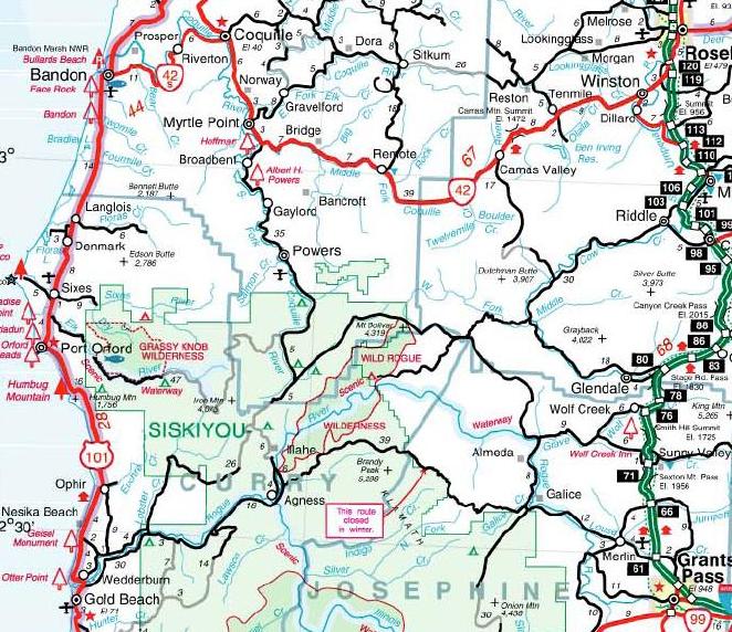
Many of us in the group have spent many hours pouring over all kinds of maps of the area, but of course the map that matters most to understanding your predicament is the map that you and James had in the car. We understand that it was map issued by the State of Oregon. Was it this one? {close up detail of area in question from the DOT map} Some news accounts made reference to you and James studying maps. Did you have more than one? Was the state-issued map the same one that James took with him when he went for help?
Folks in our group have spent lots of time figuring out things like gas mileage. It has been reported that you used a credit card to buy gas at Halsey (near Albany, which is north of Eugene) at about 5:45pm. I think that is also where you made one of the calls to the Tu-Tu-Tun Lodge. Was that, in fact, the last gas that you bought that night?
Judging from the amount of discussion devoted to it in the group, I think there will be considerable public interest in knowing what role your desire to get to the Gold Beach resort that night played in your decisions to press on. Nice place; beautiful location; key was waiting; room already paid for – some of us have been in situations like that ourselves. Did you ever consider just staying in Roseburg or elsewhere instead?
Naturally, everyone’s interested to know about the fateful decision to take the “Bear Camp” route. We understand that you told the state police that you missed your intended exit off the Interstate to Route 42. Through the blog we have learned that the sign at that exit is partially obscured by a tree branch – as you see from this picture, the part that mentions Route 42 can’t be seen easily. No wonder you missed it! How far down the road did you realize that you had? At that point, did you think you would waste too much time in turning back to find the Route 42 exit?
Some in our group have also focused on the weather conditions. They are curious whether you and James were aware of the forecast for that night. Were you driving in rain when you were on the Interstate, and did you encounter any places where it turned to snow in the higher passes along that inland route?
In considering whether or not to take the Bear Camp Route, we have wondered if you had any previous travel experience in that area (or similar territory, perhaps from your student days in Oregon). As you may know, one of the Rogue-area locals (Bob Hollenbeck) says that during the search he got a call from “[Kim?] family members down south” who told him that they thought you and/or James had been on the Bear Camp Route before.
For those who have been trying to conjecture what your exact route was (since it figures into things like the gas/miles, timelines, etc), there have been questions about which exit you took off the Internet – ooops, typo – Interstate! There are at least two exits that would have been logical: the Hugo exit (#66) or the Merlin exit (#61). I don’t think either of them mentions Galice, Bear Camp, Gold Beach, or “The Coast” on the highway exit signs, so it would have been a judgment call based on your interpretation of the map in hand. [That can be said for much of the rest of the many of the rest of the questions on our list!]
People have wondered if you stopped in Merlin as you passed through that town. Did you notice, for instance, whether any service stations there were still open? We figure your next destination would have been Galice. Any recollections of that place?
As to your route from Galice to the intersection where you were eventually rescued, we have almost as many theories as there are evergreens in the forest. All – including the locals — admit that the signage is horrible, at best. While reference is made to various roads by name – Peavine, Galice Creek, and the ubiquitous (but very confusing) Bear Camp – none of these names is listed on the state travel map. So I think the most relevant question to ask is “What road did you and James think you were on as you made your way toward Gold Beach from Galice?”
Many of us are becoming activists/lobbyists to work for improved signs in the area, so our most basic request is “Tell us what you found most confusing or misleading about them.” But we have more specific questions that have puzzled us, too:
o Assuming that you passed (and were able to see) signs that referred to possible snow/winter closings on “Bear Camp Road,” we are interested to know how you interpreted them. Arguably, the official start of winter was still a month away. And did you even know or think you were on the so-called “Bear Camp Road” at that point? Several of us wondered if you thought there was a correlation between any particular one of those warning signs on the road and the point on the state map where the red arrow points its “This route closed in winter” message box.
o There seem to be “route number signs” everywhere, with codes like 34-8-36. Were these helpful to you?
o And what about the various little signs that said “COAST”?
Saabs have a reputation as very safe cars, and yours had all-wheel drive. Did that give you and James added confidence that you could successfully handle the roads you were facing?
It has been our assumption that after driving so many miles on dark, twisty roads, there would be no way that you (or ANYONE in your circumstances) could say exactly what route you took. But some in our group who are particularly knowledgeable about the network of roads in the area might be able to get useful clues from anything you can remember about the following:
o What was it like where you had to move the rocks off the road? For instance, were there steep slopes on both sides of the road, or only one?
o Can you remember anything descriptive about where you were stuck in the snow? We understand that was particularly “hairy” to get out of.
o Some news reports said that you got as far as the Bear Camp summit or Viewpoint, which is marked with a large sign (see here for picture). Is that your recollection?
o If it wasn’t there, what can you tell us (if anything) about the point in the road where you did decide you couldn’t go further? According to reports, James had to back down the road with the car door open; can you estimate how long or how far he drove in reverse?
o Reports tell us that at some point you found a place to turn around or change direction. Can you tell us anything about that place? Did you think at that point you were starting to go back the way you came – that is, toward the east — or did you have some other thought in mind?
o What role did the presence of gates on the side roads – closed or open – figure into your wayfinding decisions?
o Reports have it that you were trying to get down below the snow line at that point, but we are curious if anything other than the precipitation gave you an indication you were climbing or descending as you drove along?
o Were you aware that night that you had driven into a maze-like complex of roads? (This is where the benefit of our perspective from studying the maps has to be tempered carefully with an understanding of what YOU knew or concluded in the days to come.)
o As you made your way to the point where you stopped for the evening, did you feel (or hope) that you were still on the main route marked on the map? Or was there some point that night that you concluded, “We’re lost!”
o At any point as you drove along did you see any other vehicles? [At one point there was a rumored report of someone seeing you drive down the mountain, but that report has never been substantiated.]
o And finally, as we have studied the aerial photos showing your car parked in that location — where three roads seem to come together — we have wondered if we are correct in concluding that the orientation of the car is a true indication the way you drove into the intersection. In other words, is the trunk of the car closest to the road you followed there, or did you turn around a bit before you parked?
Of course, when you share your story with the public, the most compelling part of it is certain to be the amazing tale of how you and James took care of your children and each other during your many long days of being stranded in that isolated place. The questions that have come up in our group about that time are relatively few in number – like everyone else, we are in awe of the strength, resourcefulness, and love that you all displayed during those harrowing times – but these minor point include
o What about your cell phone (s)? We’ve been told that a text message sent to your phone late that first night provided the clue that could help the authorities narrow the search. Did you get the message? (Someone reported that it was sent by your housesitter, although I don’t think that at that point on Saturday night anyone knew to be concerned that you were “missing.”) We understand that cell coverage is practically non-existent in that area. How long did you keep trying to get a signal?
o Were you able to get any signal on your car radio? Did you ever think someone might broadcast a “we are looking for you” message via that means?
o When did you decide to stomp out your SOS message in the snow?
o Did you or James attempt to explore the immediate area on foot in the days you were there? We understand that you were concerned about bears, but wondered if you were able to venture out far enough to get any sense of your proximity to the Rogue River, which was relatively close by (as the crow flies).
o Did you hear any helicopters while James was there, or only later on?
o And finally there were lots of questions about fire starting and other survival stuff, which I’m sure you’ll include in the story. For all of us who were boy and girl scouts, we wonder what life experiences you and James had to drawn on?
Finally, when James made the decision to go for help, we understand that you and he studied the map and came to certain conclusions about where you thought you were. This is the one area which holds the most fascination for many in our group. What can you tell us about the conclusion that you were “four miles away from Galice”? I know it must have been something that you put a lot of thought and analysis into, but of course looking at the map of where you actually were, it’s hard for us to put ourselves in your heads. There is such a fascination about what he was thinking as he began his trek down into the Big Windy Creek, and any clues that you can share would be certainly fascinating to your readers/viewers. More importantly, it would be so instructive for future search and rescue operations, which is – after all – what we are all trying to work for. Other details we hope you will include in this part of the story are
o Which of the three roads did he take as he walked away? Was that the same direction from which you had driven in?
o Did he take a cell phone with him – working or not?
o Did you and he have a plan about how he would use the girls’ toys and clothes as trail markers?
o Early reports indicated that he had snowshoes with him. Was that true?
Of course, so many of the other questions we have – about how James did what he did to save his family – will never be answered, and I for one am happy to just accept his heroic effort as testimony to the incredible power of his love for you, Penelope, and Sabine.
On behalf of the JoeDuck Blog group,
Ellen
————-
In the comments section below please feel free to ask Kati Kim specific, short, and courteous questions about her ordeal that are NOT already addressed above.
I can’t guarantee these will be addressed anytime soon or even addressed at all, so please keep that in mind.
Although people have a right to ask about anything in other venues, this page is NOT THE PLACE for any criticism and even mildly critical comments will be deleted.
AGAIN – if you comment here please be VERY brief, VERY specific, and VERY courteous. Thanks!
More questions via comments:
With deepest respect:Can you describe the status and use of your cell phones during this period? Was James the only driver?
What maps did you use and where did you get them?
- Comment by Brenda Helverson | January 2, 2007
- What elements do you feel most need to be addressed to prevent a reoccurence of your plight ?…or, put another way, what contributed most to your perception that this was a safe & reasonable route to the coast (signage, maps, other)? Comment by Paul | January 2, 2007
- What would you suggest for people to carry in their vehicles when traveling? Comment by glenn | January 2, 2007
- Kati does it make sense that this is a picture of where you turned RIGHT into the maze of logging roads, rather than the smaller road to the LEFT which goes to the coast?
http://i127.photobucket.com/albums/p135/Oregonpix/THEintersectionFS23atBLM34-8-36.jpg Comment by JoeDuck | January 2, 2007
 - Hi Kati – I’m working on trying to help get the signs
improved, and I was wondering what you remember about noticing various signs along the way, and if you didn’t really notice any of those innocuous “May Be Snowdrifts,” etc. signs until conditions became more difficult. Comment by Lisa | January 2, 2007 - What information regarding a trip itinerary do you think is important to share with your family?What activities did you discover were helpful with the children throughout all of this? Comment by glenn | January 2, 2007
- This is for Kati’s dad. What are the 10 things someone should do if they feel a loved one is missing?Is there anything you would do differently if you ever find yourself in this type of situation again? Comment by glenn | January 2, 2007
- How did you keep the babies warm? Comment by Frances | January 2, 2007 | Edit
- What lead you to choose Bear Camp Rd. as a route to the coast on that evening? Google Maps, Paper map only, Prior experience with Bear Camp? And when did you decide to take Bear Camp? When did you begin considering Bear Camp?Which paper map did you use and where did it come from?Did you fill your gas tank again after the Halsey station between Albany and Eugene? If not, why not?
Did you ask locals for advise on a route to the coast in the Albany/Halsey/Roseburg/Canyonville/Merlin areas?
Did you consider staying at the Casino motel in Canyonville when it got to be so late? (Highly visible from I5)
Did you realize a bad snow storm for the coastal mountains was in the weather forecast?
- Kati, Hi – a related sign question. The backs of those
“Snowdrift” signs are the same except they say Road “IS” blocked instead of “May Be”. Personally, I think the signs are still not as ‘eye-catching’as warning signs need to be.
Once we know what exact route you took, we will know how
many of these signs you may have passed before you really
noticed them. Do you think the same exact signs saying “ROAD IS BLOCKED” would be adequate, or do you think it would be better to have more eye-catching signs?I would like to see signs like they use for warnings in construction areas – large bright orange diamond-shaped
signs with reflective materials and lettering, with
strong warnings that Bear Camp is closed as a through route in the winter season (with dates) that dangerous conditions
are ahead, etc., all stating “NO THRU ROUTE”.I’m interested in your opinion of what you think would be
most effective and helpful. - Kati, when James left the car looking for help was there a definite understanding he would return by early afternoon that same day? If so, why do you think he did not turn around per plan? Comment by Kip | January 3, 2007
- How precise were you in your communication with the hotel in Gold Beach when you asked that the key be left out for your late arrival? Did the hotel know you were intending to travel the Bear Camp Road route?Being aware that you were leaving the freeway and taking a country road of some sort, what, if any, considerations did you have in mind for making such a transition? Comment by Fools Gold | January 3, 2007
- I would just add two perspectives to all of the above comments/questions:1 – What changes, if any, would you recommend- i.e. maps, road signs, SAR process?2 – If you could create a Public Service Announcement for preventing further tragedies – What would that message include?
- It has been reported that either you, James, or both of you once lived in Oregon, perhaps in Eugene. Is this correct? If so, did you ever explore outdoor Oregon during this time? Comment by Brenda Helverson | January 4, 2007 |

Questions for Kati go below, but for the Kim Family search discussion go here:
https://joeduck.wordpress.com/rogue-river-map/kim-family-search-in-rogue-river-wilderness-of-oregon-5
With deepest respect:
Can you describe the status and use of your cell phones during this period?
Was James the only driver?
What maps did you use and where did you get them?
Where did James intend to go when he left your car on foot on that Saturday morning?
What elements do you feel most need to be addressed to prevent a reoccurence of your plight ?…or, put another way, what contributed most to your perception that this was a safe & reasonable route to the coast (signage, maps, other)?
What would you suggest for people to carry in their vehicles when traveling?
Kati does it make sense that this is a picture of where you turned RIGHT into the maze of logging roads, rather than the smaller road to the LEFT which goes to the coast?

Hi Kati – I’m working on trying to help get the signs
improved, and I was wondering what you remember about noticing various signs along the way, and if you didn’t really notice any of those innocuous “May Be Snowdrifts,” etc. signs until conditions became more difficult.
What information regarding a trip itinerary do you think is important to share with your family?
What activities did you discover were helpful with the children throughout all of this?
This is for Kati’s dad. What are the 10 things someone should do if they feel a loved one is missing?
Is there anything you would do differently if you ever find yourself in this type of situation again?
How did you keep the babies warm?
What lead you to choose Bear Camp Rd. as a route to the coast on that evening? Google Maps, Paper map only, Prior experience with Bear Camp? And when did you decide to take Bear Camp? When did you begin considering Bear Camp?
Which paper map did you use and where did it come from?
Did you fill your gas tank again after the Halsey station between Albany and Eugene? If not, why not?
Did you ask locals for advise on a route to the coast in the Albany/Halsey/Roseburg/Canyonville/Merlin areas?
Did you consider staying at the Casino motel in Canyonville when it got to be so late? (Highly visible from I5)
Did you realize a bad snow storm for the coastal mountains was in the weather forecast?
Kati, Hi – a related sign question. The backs of those
“Snowdrift” signs are the same except they say Road “IS” blocked instead of “May Be”. Personally, I think the signs are still not as ‘eye-catching’as warning signs need to be.
Once we know what exact route you took, we will know how
many of these signs you may have passed before you really
noticed them. Do you think the same exact signs saying “ROAD IS BLOCKED” would be adequate, or do you think it would be better to have more eye-catching signs?
I would like to see signs like they use for warnings in construction areas – large bright orange diamond-shaped
signs with reflective materials and lettering, with
strong warnings that Bear Camp is closed as a through route in the winter season (with dates) that dangerous conditions
are ahead, etc., all stating “NO THRU ROUTE”.
I’m interested in your opinion of what you think would be
most effective and helpful.
Kati, when James left the car looking for help was there a definite understanding he would return by early afternoon that same day? If so, why do you think he did not turn around per plan?
How precise were you in your communication with the hotel in Gold Beach when you asked that the key be left out for your late arrival? Did the hotel know you were intending to travel the Bear Camp Road route?
Being aware that you were leaving the freeway and taking a country road of some sort, what, if any, considerations did you have in mind for making such a transition?
I would just add two perspectives to all of the above comments/questions:
1 – What changes, if any, would you recommend- i.e. maps, road signs, SAR process?
2 – If you could create a Public Service Announcement for preventing further tragedies – What would that message include?
It has been reported that either you, James, or both of you once lived in Oregon, perhaps in Eugene. Is this correct? If so, did you ever explore outdoor Oregon during this time?